Mae Hong Son

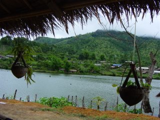
The first two photos in this posting are from Bahn Rahk Thai. The third photo is Mae Hong Son from the wat on the hill.
It's almost 10 in the evening here, our second night in Mae Hong Son. Yesterday we took a four hour bus ride from Pai, winding our way through the hills between limestone cliffs studded with caves.
A few impressions of Pai that I didn't get a chance to put in my last post: like I said, I was expecting more farangs and tourism, but instead, found Pai to be an interesting crossroads for many different cultures. We saw Muslim women in burqahs speeding by on scooters, Lisu women in bright tribal dress walking through the town, and ate Shan cuisine at restaurants for farangs.
As beautiful as Pai is, I'm absolutely stunned by the area around Mae Hong Son. The town is situated on a tiny lake and ringed with green hills. Today, we took a motorbike out to Tham Pla National Park, the location of Fish Cave. Beautiful blue dace fish, which grow up to a meter long, swim in the cave and the pools around it. It's considered a very holy spot, and a lucky thing to feed the fish, which we did. On the other hand, it's very unlucky to eat the fish.
By the way, the word 'suoy' with a rising inflection means beautiful, while with a low inflection means unlucky.
While we were at the park it started pouring and we took refuge in a bamboo hut with two middle-aged Thai women. Zander had a phrasebook so we were able to have a rudimentary conversation.

After a contemplative hour in the rain, we headed towards the Myanmar border. We're not actually planning on crossing into Myanmar until next week. Instead, we were interested in exploring a tiny KMT town about 5 km. from the Burmese border. In the early '70s, KMT fighters were responsible for quelling Communist insurgents in northern Thailand and also fighting against the Burmese army. (They were also known for their involvement in the drug trade, but the Thai government turned a blind eye on this.) As a result of their aid, the tiny town on the border is known as Bahn Rak Thai (Thai-loving village). It's a peaceful town on a lake with Chinese influence, almost haunting in its calm. Red Chinese latterns hang from huts with clay walls and bamboo roofs. There's no sign of the old fighting, though it's possible to take a mule the last 5 km to the border to see where the KMT trenches were during the fighting. It's a dirt track, impassable by standard motorbike. In short, we'd reached the end of the road.
We had lunch at a little hut on the river and sampled the local oolong tea and wines-- lychee, pineapple, tamarind, and plum. The tea was most likely planted as crop substitution for the old crop, opium.
The road up to Bae Saw (the other name for this town), curved through tiny Shan villages and up in the mountains, where we were sometimes going up or down a 35 degree grade. The hills were lushly forested, and we stopped both at Pang Pong Palace and a waterfall on our return ride. There was old-growth bamboo and near the waterfall trees as big as any Doug Fir in the Pacific Northwest.
It's going to be hard to leave this town. Yesterday, when we arrived, we went up to a wat on the top of the nearby hill, which treated us to a lovely view of the city. We are almost in the clouds. At the top of the hills there is actually sub-alpine forest.
Tomorrow we will most likely be winding our way back towards Chiang Mai, spending the night in either Soppong or Pai. In the hills the buses stop at checkpoints and police with M-16s go through the papers of Thais on the bus. It's basically racial profiling; the Thai government doesn't want Burmese refugees and people from the hill tribes to move to the larger cities and take jobs.
Nobody checks our papers, which is a good thing, since they're in Chiang Mai.
We'll be getting back to Chiang Mai on Friday, picking up our passports, and then making our way to the northernmost tip of Thailand and the Burmese border, by way of Chiang Rai and Mae Sai.


0 Comments:
Post a Comment
<< Home